Index of German maps Messtischblatt in scale 1:25000 (North-east part, covering East Prussia, NE Poland, parts of Lithuania, Belarus). Blue (and green) marked sheets are available.
Messtischblatt (German Meβtischblatter, Generalstabskarte, topografische Karte TK25) German topographic map in scale 1:25000 (1 cm - 250 meters or 4 cm - 1 km), characterized by high accuracy, detail mapping territory. Messtischblatts were produced and published since XIX-th century till 1945. They are one of the best sources of information about the transformation of the terrains that occurred in nature over the past 100-150 years.
Proponent of Messtischblatts was Muffling, who in the Order of the 1821 year suggested a totally new system for mapping, which was based on polyhedral mapping. Survey and maps cover only territories of Germany, including Memel (Klaipeda) district (part of present Lithuania). Messtischblatts have size 10′ longitude and 6′ latitude. Longitude was considered from Ferro (first editions), later from Greenwich (difference -17°40′). After I WW work on updating and compiling of maps was continuing. Full coverage of the country map obtained in the 1931 year. In parallel topographers work on introduction of the Gauss-Kruger projection. Work on this project was completed in 1927 year. In addition kilometer grid DRG (Deutsches Reiches Gitter) was implemented. In 1936 year the previous numbering of continuous sheets has been replaced by a new, in which the first two digits show row and another - position of map in row.
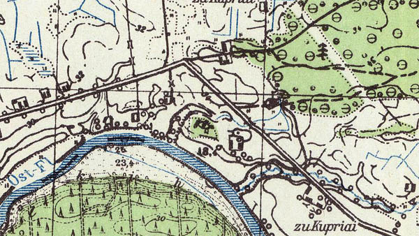
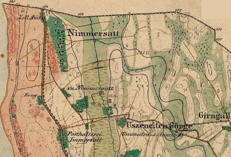
Messtischblatts published in 1910-1913 (see index sheet) covering Memel (Klaipeda) district (44 Messtischblats fully covering district). These maps printed in 2 colors: all content except water in black, water in blue. Territories outside Germany are not showed (white). Relief was shown by horizontals.
_Nimmersatt_1912.jpg)
Fragment of Messtischblatt 1 Nimmersatt (1:25000, 1912)
During I WW German topographers using old Russian cartographic material prepared and published set maps in scale 1:25000 which covers territories outside Germany (west Russia) named "Russischen karte des Westlichen Grenzgebiets". This set covers Poland, Lithuania, Latvia, Estonia, partially Belarus, Ukraine.
In period between I and II WW German topographers revised cartographical material, some Messtischblatts were updated according recognitions. Colored maps were published (see example below).

Fragment of Messtischblatt Nr. 1193 (147) Laukischken (1939, 1:25000)
Messtischblatts published during II WW partially covering territories of neighbor countries (Poland, Lithuania, Belarus...). On Messtischblatts from this edition territories of neighbor countries are shown (differently as in previous editions). Content to borderline sheets was transfered from old cartographic material of different countries. Also Messtischblatts cover territories which were involved into German Reich (after beginning II WW, part of present Poland, Lithuania, Belarus, see index sheet). Parallel other sets of German maps in scale 1:25000 were prepared and published (see article about German II WW maps in scale 1:25000).
Fragment of Messtischblatt Nr.10102 Grenzhöhe (1944, Deutschen Reich 1:25000)

Fragment of Messtischblatt Nr.17101 Dubeningen (1944, Deutschen Reich 1:25000)
At the end of II WW Color Messtischblatts based on Basic map in scale 1:5000 (Grundkarte 1:5000) were released. It should be rated as new generation of Messtischblatts. Reljef on these maps was shown by brown horisontals, water in blue, woods in green, other elements in black color.
Fragment of Messtischblatt Nr.17102 Unterfelde (1944, Deutschen Reich 1:25000)
More about German maps in scale 1:25000 (Messtischblatts) in Vademecum Ost, 1 Auflage, 1940.

Fragment of Messtischblatt 12103 Schirwindt (1:25000, 1940)
Full list of available (digitalized not less than 300 dpi) German TK maps in scale 1:25000 (Messtischblatt) you can find THERE. (inside of area of my interests)
List of available Messtischblatts (outside of area of my interests) you can find THERE. Biggest part of them are republished by AMS after II WW.
List of geological Messtischblatts you can find THERE (fragment of index sheet).

Fragment of geologic Messtischblatt Nr. 17 Memel (1:25000, 1911-1912)
Fragment of agronomic Messtischblatt Nr. 1899 Gr.Duneyken (1912, 1:25000)
Separately we should describe old edition of Messtischblatts (called Urmesstischblatt). Till now we can find literature about Urmesstischblatts, which cover Memel districkt. First Urmesstischblatts on territories of Klaipeda (Memel) region (and East Prussia) were prepared and published in 1832-1834 (First edition). Topographic survey was based on triangulation (1830 *).
Content on maps from set of First edition of Urmesstischblatts is displayed in color, using new topographic signs and symbols. The relief showing by shading. Longitude was calculated from Ferro (on the corners of maps were shown coordinates). On frames of maps additional information is given: the name of the sheet, when and who prepare map (usually maps were prepared by officers of the artillery). The content of the maps outside of Prussia is not displayed.
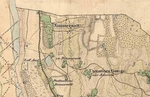
Fragmant of Urmesstischblatt 1 Nimmersatt (1:25000, 1834).
The second issue of Urmesstischblatts of Prussian Army was developed and published in 1860 * year. Maps show all Prussia. Content is updated according new survey. On frames of maps from this edition additionaly are trigonometric points given. Reljef shown by horizontals, value of high was on frames given. Adopted continuous numbering of map sheets remained until 1936 (see index map).
Fragmant of Urmesstischblatt 1 Nimmersatt (1:25000, 1860, second issue)
Owner of original maps - department of Prussian Heritage of Library Berlin
Separate topic can be about alteration of name of populated place-names in East Prussia. Changes were reflected also in topographic maps. Place-names of Baltic genesis were changed according decision in 1938, changes were reflected as in all cartographic material (after 1938) as in Messtischblatts (examples see below).
_Darkehmen_1927.jpg)
Fragment of Messtischblatt 347 Darkehmen (acc. new numeration 1598), published in 1927.
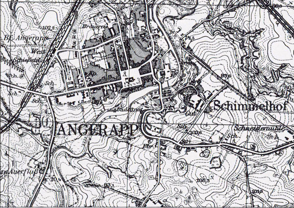
Fragment of Messtischblatt 1598 Angerapp, published in 1938 (as you see Darkehmen become as Angerapp)
List of place-names in East Prussia and changes as in 1938 as in 1945 you can find THERE.
All alteration of name of populated place-names in East Prussia you can find in map New place-names of East Prussia (original name of map Neue Ortsnamenkarte der Provinz Ostpreussen, scale 1:200000, 1938). (link, map will open in new window)
After II WW (in 1945) all place-names in part of East Prussia which come to Soviet Russia were changed... As example you can see fragment of soviet map in scale 1:25000 published in 1955. (No Darkehmen, no Angerapp only Озёрск...)
Updated 2015 11 06


