1:10000 (1939-1945, II WW period, sets Russland 1:10000, Ostland 1:10000)
During II WW German topographers prepared and published maps in scale 1:10000 (100 meters in 1 centimeter in the map). Maps at this scale mostly were prepared and published on strategic territories, like big cities, aggregate of units and ect.. Maps in scale 1:10000 were prepared using cartographical large-scale material (as example maps in scale 1:25000, plans) and updated using aero picture.
Russland 1:10000: maps in scale 1:10000 (set Russland 1:10000) have dimension 3′20″ latitude x 7′30″ longitude. Longitude was considered from Greenwich. Map from this set was not typical: map in scale 1:10000 has size 1/6 of map in scale 1:50000 (see below), usually maps in scale 1:10000 have size 1/16 of 1:50000 maps. Size of 1:10000 maps approximately 80x70 cm (quite big).
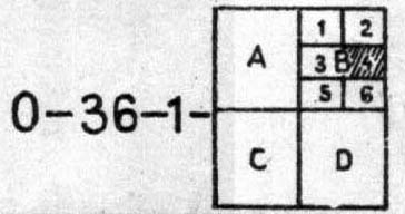
Scheme of composing of German II WW maps in scale 1:10000 (Russland 1:10000)
On frames additional information was given: name of set (Russland 1:10000), name of map (example O-36-1-B-4 Leningrad), information which cartographical material was used by preparing map, date and area of aero picture, date of publishing, publisher. On maps in scale 1:10000 was kilometrical net, relief was shown by contours.
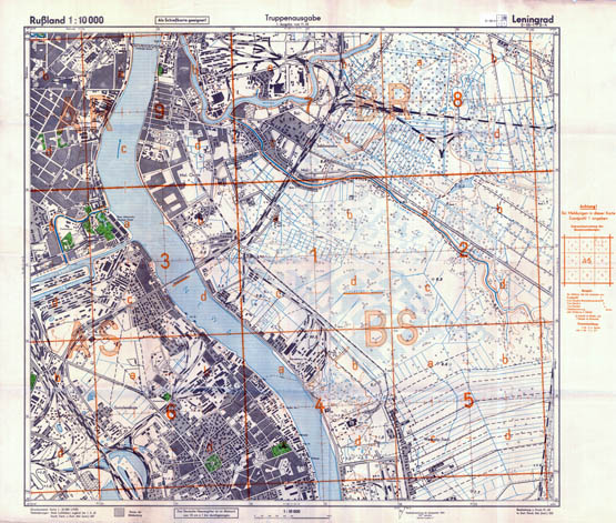
As example - general view of German map in scale 1:10000 O-36-1-B-4 Leningrad (set Russland 1:10000)
Ostland 1:10000: maps in scale 1:10000 (set Ostland 1:10000) have dimension 2′ latitude x 3′ longitude. Longitude was considered from Greenwich. Map from this set was not typical: map in scale 1:10000 has size 1/25 of map in scale 1:50000 (see below), usually maps in scale 1:10000 have size 1/16 of 1:50000 maps.

Scheme of composing of German II WW maps in scale 1:10000 (Ostland 1:10000)
On frames additional information was given: name of set (Ostland 1:10000), name of map (example O-35-89-d-3 Sili), information which cartographical material was used by preparing map, date and area of aero picture, date of publishing, publisher. On maps in scale 1:10000 was kilometrical net, relief was shown by contours.

As example - general view of German map in scale 1:10000 O-35-89-d-3 Sili (set Ostland 1:10000)


