2024-03-19 06:36:02
Navigation
MAPS
· Atlases

We are recommending

Exhibition

Exhibitions

Exhibition

1:200000 (1806-1917)
Index sheet of available Reymann's maps in scale 1:200000 (last edidions)
German maps in scale 1:200000 on territory of central Europe, known as Reymann maps (Reymann's Karte, Reymann'sche Karte) were published in 1806-1908 (republished till 1915) in collections: "Special topographic map of Germany" (Topographische Special-Karte von Deutschland), "The special topographic map of central Europe" (Topographische Spezialkarte von Mitteleuropa). Maps called "Reymann maps" in honour of inspector of maps Depot of Prussian Army Daniel Gottlob Reymann (1759-1837), who started publishing a collection of maps. These maps produced: D.H. Reymann (1806-1836), Heinrich Berghaus (1836-1846), Carl Flemming (1846-1874), and General Staff of Prussian Army (1876-1908).
Reymann map in scale 1:200000 covering the territory of 68x48 km. Sheet of maps have form a rectangle, the size of the frame -34x23 cm. Maps were produced in a conical projection, longitude considered from Ferro. Maps were printed in one colour.
On beginning of the First World War was published collection colour maps in scale 1:200000 based on Reymann maps for purposes of pilots - 
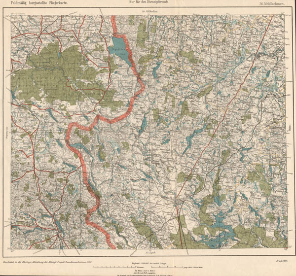
"Feldmassig hergestellte Fliegerkarte". All available maps from collection "Feldmassig hergestellte Fliegerkarte" you can see on index sheet THERE.
Reymann maps for want of Russian Empire maps in scale 1:42000 (1:84000) were used in preparing maps in scale 1:100000 of collection "Karte des westlichen Russlands" (maps of western Russia) in 1912-1917.
Index sheet of available Reymann maps (published till 1874) you can find THERE.
Reymann'sche Karte 1:200000
Map 161 Grodno (set Topographische Spezialkarte von Mitteleuropa), 1914, general view.

Feldmässig hergestellte Fliegerkarte
Map Nr. 36 Mehlkehmen (set Feldmässig hergestellte Fliegerkarte), 1917, general view

As example Map Nr.36 Mehlkehmen, 1917 (link, 15 MB), Map Nr.35 Goldap (link, 15 MB), Map Nr. 20 Pillkallen (link, 15 MB). Maps provided courtesy Stefan Fründ (http://eisenbahn-gumbinnen-goldap.de)
Fragment of map 081 Nowo-Alexandrowsk in scale 1:200000 from collection Reymann’s maps and map XI-4 in scale 1:126000 from collection maps of Russian Empire in scale 1:126000 (tree werst maps).
German maps in scale 1:200000 from catalog "Topographische Ubersichtskarte des Deutschen Reiches" (index sheet)

German maps in scale 1:200000 from catalog „Topographische Ubersichtskarte des Deutschen Reiches“ cowers territories of Germany. On territories of present Lithuania (Klaipeda/ Memel district) were made 5 maps from this catalog. According literature "Das Reichsamt fur Landesaufnahme und sein Kartenwerke", Berlin 1931, verlag 1940) published were only 3 maps on territories of present Lithuania: 1 Memel, 2 Paaschken and 5 Rossiten. (Scans all this maps are in collection).

Size of maps from catalog „Topographische Ubersichtskarte des Deutschen Reiches“- 60'x30'. Each map in scale 1:200000 consists of 4 maps in scale 1:100000. Maps from catalog „Topographische Ubersichtskarte des Deutschen Reiches“ were published in color. Projection-conical, longitude was considered from Ferro.

Topographische Ubersichtskarte des Deutschen Reiches

Map 5 Rossitten (set Topographische Ubersichtskarte des Deutschen Reiches), 1913, general view

Languages, Kalbos, Языки
I like maps4u.lt
Login
Username

Password


Not a member yet?
Click here to register.

Forgotten your password?
Request a new one here.
Google
Counter
Hey.lt - Nemokamas lankytojų skaitliukas
Render time: 0.02 seconds 3,732,249 unique visits