Index sheet of RKKA maps in scale 1:1000000
RKKA (red army of workers and peasants) maps in scale 1:1000000 (1 cm-10km) published as maps having international frames have dimension 4 deg. of latitude and 6 deg. of longitude (maps have trapezium shape). Longitude is counted from Greenwich. Projection - polyhedral. Maps were printed in color. To collection we collected these RKKA maps in scale 1:1000000 (on index sheet these maps marked in blue, see above):
I-39, I-40, I-42, I-43, I-44.
J-29, J-30, J-31, J-32, J-33, J-34, J-35, J-36, J-42, J-44.
K-29, K-30, K-31, K-32, K-33, K-34, K-35, K-36, K-39, K-40, K-44.
L-32, L-33, L-34, L-35, L-36, L-37, L-38, L-51.
M-29, M-30, M-31, M-32, M-33, M-34, M-35, M-36, M-37, M-38, M-39, M-49, M-51, M-52.
N-29, N-34, N-35, N-36, N-37, N-38, N-39, N-42, N-47.
O-33, O-34, O-35, O-36, O-37, O-42, O-43.
P-33, P-34, P-35, P-36, P-37.
Q-35, Q-36, Q-37.
R-35, R-36, R-37.
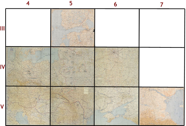
General staff of RKKA also published maps in scale 1:1000000 which weren't in international frames. Maps of this set have rectangular form and have dimension appr. 6 deg. of latitude and 10 deg. of longitude.Longitude is counted from Greenwich. Maps were printed in color. Relief shown in color scale. Name of maps from this set composed from two numbers (first one-Roman shows row, second-Arabic shows position of sheet in row) and name of biggest city (example: V-5 Киев). On margins except name of sheet are given scale, publisher, date of publishing, position of sheet, signs, other information.

Index sheet of RKKA maps S1:1000000 (East Europa), non international version.
To collection we gathered these maps:
III-5.
IV-4, IV-5, IV-6,
V-4, V-5, V-6, V-7.

