Karte Europaisches Russland 1:126000 (1914-1917). Index sheet.
During I WW German topographers (Kartogr. Abt. d. Stellv. Generalstabes d. Armee) parallel with sets of maps "Karte des westlichen Russlands (1:100000)" and "Russischen karte des westlichen grenzgebiets (1:25000)" published set of maps in scale 1:126000 (3-werst) "Karte Europaisches Russland 1:126000" (In literature sometimes set named Karte von Russland). Maps from this set were prepared using 3-werst maps of Russian empire. It will be observed, sets "Karte Europaisches Russland 1:126000", "Russischen karte des westlichen grenzgebiets (1:25000)" and "Karte des westlichen Russlands (1:100000)" partially are on identical territory, but basis of these sets are different - maps from set "Karte des westlichen Russlands (1:100000)" were prepared using mostly 2-werst (1:84000) maps of Russian empire, maps from set "Russischen karte des westlichen grenzgebiets (1:25000)" were prepared using 1-werst maps of Russian empire, maps from set "Karte Europaisches Russland 1:126000" were prepared using 3-werst maps of Russian empire.
Maps from set "Karte Europaisches Russland 1:126000" as maps from original set were printed on sheets with dimension 58x41 cm (app.), every 20 minutes drawn grid. Longitude was shown from Pulkowo and from Paris. Maps from this set were printed in one color (on some sheets rivers and lakes colored in blue, woods in green). Relief was shown by shading (Lehman scale).
Content of maps from set "Karte Europaisches Russland 1:126000" is the same as in original 3-werst maps of Russian empire. Only same differences can by mentioned: all name of populated places were written in German, lines, which shows position of maps from set "Karte des westlichen Russlands (1:100000)" on the map from set "Karte Europaisches Russland 1:126000" if maps were on the same territory, were drawn in black lines.
Names of maps from set "Karte Europaisches Russland 1:126000" were as in original: first number (in Romanian numbers) show row, second number (in Arabic numbers) show position in row (in orig. German - Reihe хх Blatt уу), additionally was given name of biggest population places on map. On Margins was given additional information: main topographical signs, names of administrative units which covered map, translating of abbreviations (RU-GE).
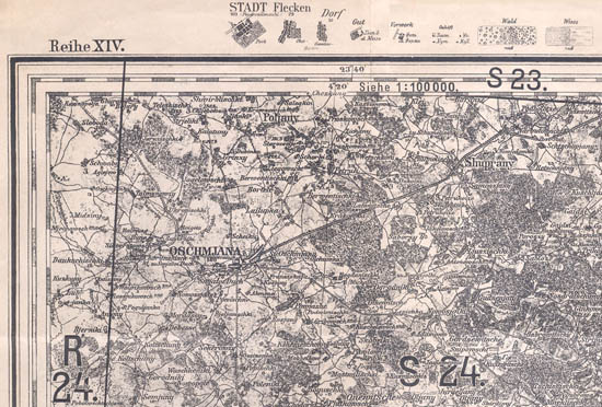
Fragment of map from set "Karte Europaisches Russland 1:126000".


