Maps prepared by F.C..von Schmettau and F.W. von Schulenbug-Kehnert (1760-1790)
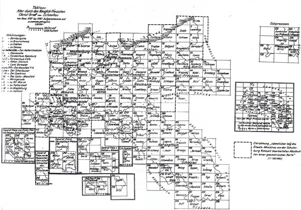
The administration of Prussia in the second half of the seventeenth century had task to create a single large-scale map of the whole of Prussia. In order to implement these plans, in 1760-1790, led by the Minister, General Friedrich Carl von Schmettau and F.W. von Schulenbug-Kehner was developed Map provinces of the Prussian kingdom in scale 1:50000. This set consists of about 940 maps, 25 manuscripts, 15 indexes and 2 descriptions (see index map below). Most of the maps from this set covers the western territories of Poland, east territories of present Germany. In some sources, this set is also called Cabinet map (Kabinettskarte preussischen Provinzen ...). The whole map was not published; issued were separate sheets or sets covering individual administrative units. Map created using different cartographic material, but not based on a integral triangulation network.

Index sheet of
Map of provinces of the Kingdom of Prussia in scale 1:50000 created by Friedrich Carl von Schmettau and F.W. von Schulenbug-Kehner
(increase)
Interestingly, some sheets of Map of provinces of the Kingdom of Prussia in scale 1:50000, created by Friedrich Carl von Schmettau and F.W. von Schulenbug-Kehner, covers a territory of Lithuania and Prussia, see the index map below:
Fragment of Index sheet of Map of provinces of the Kingdom of Prussia in scale 1:50000 created by Friedrich Carl von Schmettau and F.W. von Schulenbug-Kehner, territories of East Prussia
Another interesting fact that some maps (not reference to Map of provinces of the Kingdom of Prussia in scale 1:50000) from the same period displays similar or identical territories as the Map of provinces of the Kingdom of Prussia in scale 1:50000 created by Friedrich Carl von Schmettau and F.W. von Schulenbug-Kehner (East Prussia), have the same scale. Possible assumptions: it is maps from set Map of provinces of the Kingdom of Prussia in scale 1:50000 (but not marked), or these maps as a background to Map of provinces of the Kingdom of Prussia in scale 1:50000.
Fragment map named Gegend südöstl. Gumbinnen zwischen Pissa, Rominte u. Schwenteine (map of the south of Gumbinnen between the rivers Pisa, Rominte and Schwenteine) scale 1:50,000, 1780, no creators, no publishers...
Literature:
Andrzej Konias: "Kartografia topograficzna państwa i zaboru pruskiego...".
B.Olszewicz "Polska kartografja wojskowa...".

