|
|
|
1:1680000 (40-verst maps) |
|
|
Military-road maps of part Russia and neighbor countries in scale 1:1680000, 1829 y. publisher F.F. Shubert
Set of Military - road maps of part Russia and neighbor countries in scale 1:1680000 (40 verst per inch) originally named "Военно - дорожная карта части России и пограничных земель" was published in 1829. This set of maps was prepared by general of Russian Empire army F.F. Shubert, published by Military - topographical Depot (orig. Военно - Топографическое Депо). Set consists of 8 maps named by Roman numbers (from I to VIII). On first sheet of maps set name of set, publisher, creator were given. On second sheet administrative partition of neighbor states, biggest part of topographical signs and symbols were given. On all sheets we can find part of topographical signs and symbols, name of set, name of sheet, name of drawers, scale. Maps from set of Military - road maps of part Russia and neighbor countries in scale 1:1680000 were printed in color. All content was printed in black, lines and boundaries of administrative units in color. Set of Military - road maps of part Russia and neighbor countries in scale 1:1680000 analogous to generalized set of Russian empire maps in scale 1:420000 (10-verst per inch) prepared by F.F.Shubert.
In collection we have I-IV digitalized maps from this set.
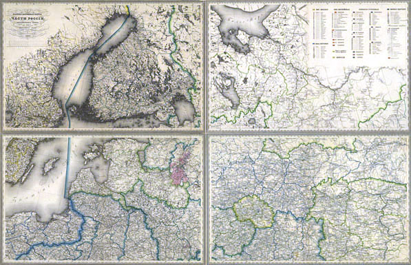
Territories of Russia and neighbor countries covered by I-IV sheet of set Military - road maps of part Russia and neighbor countries
"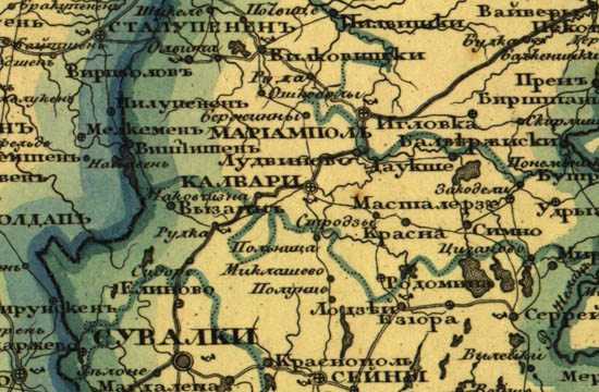
Fragment of map from set "Military - road maps of part Russia and neighbor countries"
|
|
Strategic map of Central Europe, 1:1680000 (40 miles to the inch)
Strategic map of Central Europe in scale of 1:1680000 (40 miles per inch, original name Стратегическая карта средней Европы) covers territory of Central and Eastern Europe and was produced by topographers of empire of Russia from the late 19th century until the Second World War (see index map below).
Index sheet of Strategic map of Central Europe in scale of 1:1680000
The size of rectangular sheets of Strategic map of Central Europe - 6 degrees latitude and 20 degrees of longitude (at 60 parallel). Longitude was considered from Ferro. Maps from this set were named by Roman numerals (I to XII, see index map). Maps were published in 4 colors: black content, water - blue, forest - green, relief - brown. On frames of printed additional info: conventional signs and symbols, the year of renewal and print, scale.
Fragment of map V from set Strategic map of Central Europe in scale of 1:1680000, 1915 (Lithuania).
|
|
Map of European Russia and Caucasus region, 1862 (index, active link)
40 verst per inch (1:1680000) map titled "European Russia and the Caucasus region map" prepared by military topographic depot and in 1862 published by Imperial Russian Geographical Society. The original name of this map "Карта Европейской России и Кавказкого края, составленная по новейшим сведениям при Военнр-топографическом депо и изданная Императорским русским географическом обществом в 1862 года.". The map consist of 12 sheets of size 24° longitude × 8° latitude. Longitude considered from Pulkovo and from the 1-st meridian. On the first page was given the name of map, on page 10 - conventions and signs. The current Lithuanian territory displayed on 4 and 7 map's sheets.
General view of 4-th map from set " European Russia and the Caucasus region map" (1:1680000, 1862), link to full size map
|
|
|
|
Not a member yet? Click here to register.
Forgotten your password? Request a new one here.
|
|


