2024-10-04 15:29:16
Navigation
MAPS
· 1:10000
· 1:25000
· 1:5000
· INDEXES

We are recommending

Exhibition

Exhibitions

Exhibition

LITHUANIAN (1918-1940) MAPS
Topography department publications which are described in 1939 publications catalogue of Military topography department of GS MoD (link)
In 1918 independent Lithuania territory was covered by maps of former Russian Empire (verst scale maps) and topographical maps of Kaiser Germany, which administrated Lithuania after War World I. Most of German WWI maps were made using maps of Russian Empire. For Lithuanians it was hard to interpret old maps, because these maps were in foregn languages, names of objects were perverted, information on maps were aged. Old maps were used till 1924, when military topographic office (Military Topography section)  at General staff was established. In 1929  Topography section grow to the Topography department. It was concluded that basic map will be map in scale 1:25000. Till Second World War it was released 19 original maps and 73 recognized maps. (about  1/6 the territory of Lithuania). It was planned to prepare 823 (with the edge of the occupied Vilnius) or 542 (at the time the current territory of Lithuania) maps in scale M1:25000.
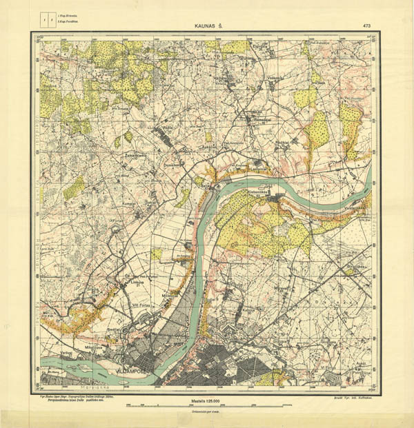
Lithuanian map 1:25000
General view of inter-war Lithuanian maps in scale 1:25000, map 473 Kaunas Š (North part of city Kaunas), more about maps in scale 1:25000 (with full size examples) [link]

Maps in smaller scale 1:100000 were drawn using maps in scale M1:25000 by generalizing sheets, and where the photo (survey) was not yet done, using German S1:100 000 maps, correcting them according aerophotographical picture or recognition results. Till Second World War it was prepared 44 (+4) maps in scale 1:100000 to cover about 2/3 of the territory of Lithuania.

Lithuanian map in scale 1:100000
General view of Lithuanian map in scale 1:100000 (map 1708 Lentvaris-Vilnius, 1940), more about maps in scale 1:100000 (link)

A third yet smaller scale maps were in 1933 published (in two sheets) in scale 1: 400 000 maps covering all of the ethnographic territory of Lithuania. This map was published in 5 variants.

map of Lithuania
General view of Lithuania map in scale 1:400000, 1933, variant A, more about map in scale 1:400000 (link)

More about Lithuanian Topographers you can find at Lithuanian part of maps4u.lt (link).
More about literature published by Military Topographic ofice and military topographers you can find at Lithuanian part of maps4u.lt (link).

Also more information about Lithuanian inter-war maps (1918-1940) and all published maps you can find on Digital publication:
Updated 10 MAY 2012
Administrative divisions of inter-war Lithuania (acc. 1923 inventory)
Maps (below) show administrative divisions of inter-war Lithuania according inventory from y. 1923.
Lithuania was divided into counties (apskritis), townships (Valsčius).

Administrative division of Lithuania
Administrative division of inter-war Lithuania into counties (Apskritis) acording 1923 inventory. Large map (link). Map courtesy XrysD.

Administrative division of Lithuania
Administrative division of inter-war Lithuania into counties (Apskritis) and Townships (Valsčius) acording 1923 inventory. Large map (link). Map courtesy XrysD.

Literature.:

1. Lietuvos gyventojai: pirmojo 1923 m. rugsėjo 17 d. visuotinio gyventojų surašymo duomenys. Kaunas: Lietuvos Respublikos Centrinis Statistikos Biuras, 1923. lxix, 311 p. [380 p.]

2. Lietuvos apgyventos vietos: pirmojo visuotinojo Lietuvos gyventojų 1923 m. surašymo duomenys. Kaunas: Centralinis Statistikos Biuras, 1925. viii, 735 p. [743 p.]

3. Mapa rozsiedlenia ludnosci Litewskiej ... 1:750000, 1929.

Languages, Kalbos, Языки
I like maps4u.lt
Login
Username

Password


Not a member yet?
Click here to register.

Forgotten your password?
Request a new one here.
Google
Counter
Hey.lt - Nemokamas lankytojų skaitliukas
Render time: 0.03 seconds 3,840,926 unique visits