|
Index sheet of 1:84000 maps (above Baltic countries, Poland, Belarus, Ukraine, link)
Maps in scale 1:84 000 (Two-verst map of west borderland of Russian Empire) (orig. named Двухверстовая карта западного пограничного пространства) started printing in 1883. As original survey (mostly in scale 1:21000, later - 1:42000, 1:84000) as maps in scale 1:84000 cover territories of presents Finland, Estonia, Latvia, Lithuania, Poland, west Belarus, Ukraine. Maps in scale 1:84000 (two verst per inch) on bigest part the territory of Lithuania was printed in 1907 - 1915. Maps in scale 1:84000 were as basic topographic maps in the First World War in Russian army. Sheets of maps in scale 1:84000 are trapezium, frame sizes - 27' longitude and 15' latitude, or 34,3 x33,1 cm (at 55 ° parallel). Longitude is calculated from Pulkovo. Sheets numbered by two numbers: first Roman indicates row, second Arabic indicates position of map in row. (See index sheet). Map were prepared in two colors: brown color of the horizontals and all other content - in black.
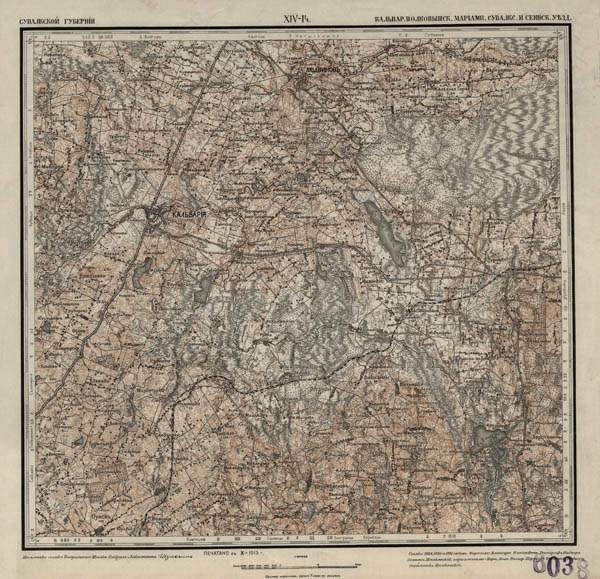 General view of Two-verst map (1:84000) of west borderland of Russian Empire, sheet XIV-14 (two-colour edition)
On some territories Two-verst map of west borderland of Russian Empire was printed in five colours, additional green colour shows woods, blue - waters, red - roads.
General view of Two-verst map (1:84000) of west borderland of Russian Empire, sheet III-19 (5 colour edition)
On some territories Two-verst map of west borderland of Russian Empire was printed in three colours, additional blue colour shows waters.
General view of Two-verst map (1:84000) of west borderland of Russian Empire, sheet VIII-22 (3 colour edition). It is interesting that map VIII-22 is compiled using also old 3-verst maps (1:126000) of Russian Empire. Some territory had no survey (0,5, 1 or 2 -verst survey) and topographers need use fragment 1:126000 map (no relief).
On maps under the villages and towns bear the names of the number of yards. From 1:21 000 scale field in the original composing map moved almost all of the network design with low bridged and the water passes. Mark hydrographic elements starting on drainage ditches. Forest areas on the map densely fill the 0,6 - 0,8 mm diameter roller, without distinction between coniferous and deciduous stands in marked clearing, felling and scrub. On the maps in scale 1:84 000 horizontals lead every 2 or 4-fathom.
RKKA (Red army) in y. 1920-1930-th (observed maps printed in 1938-39) republished Two-verst maps (1:84000) of west borderland of Russian Empire, interesting that some maps were updated on newest cartographic material (WIG maps S1:100000, Baltic States maps), some maps were printed without changes (as originals).
Also WIG ( Wojskowy Instytut Geograficzny) in 1920-23 republished Two-verst maps (1:84000) of west borderland of Russian Empire without changes, maps were only rescaled to scale 1:100000 (all or part names of populated places were traslated into Polish, names on maps were or acc. Two-verst maps (1:84000) of west borderland of Russian Empire (+ name of bigest population place) or like First-tipe WIG maps (or mixed). On index of Two-verst maps (1:84000) of west borderland of Russian Empire in blue shown available (digitalized) maps.
 |
|
Fragment of 2-verst (1:84000) map XIII-22, survey 1910, map printed in 1916, present Belarus (original map)
|
 |
| Fragment of 2-verst (1:84000) map XIII-22, survey 1910, map printed in 1927 by RKKA, (no changes) |
 |
| Fragment of WIG map in scale 1:100000 XIII-22 Kurzeniec, 1921 (place-names partially translated into Polish, no changes) |
 |
| Fragment of WIG map in scale 1:100000 XIII-22 Kurzeniec, 1922 (place-names fully translated into Polish, no changes) |
 |
| Fragment of map T-23 Isha from set Karte des Westlichen Russlands, 1917, map published acc. 1:84000 maps. |
 |
| Fragment of map T-23 Iza from set Karte des Westlichen Russlands, 1919, map published acc. 1:84000 maps. |
| Comparison of verst scale maps of Russian empire (the same territory, maps and survey from period 1880-1917) you can find THERE. |
|
List of all digitalized 2-verst maps (1:84000) rows 0-XXIII with main characteristics (date of survey, date of recognizing, date of publishing, publisher, remarks) you can find THERE.
|
|
Territories (present Latvia, Estonia, west borders of Russia in north of 58 parallel were covered by maps from north zone of maps from set “Двухверстная карта западного пограничного пространства“ (Map of west borderland, scale 2 verst per inch/1:84000), (rows IIIc-XIc, Finland - Xc-...). Letter C (in Cyrillic) in name of map indicates that map belongs to north zone (as example of name IVc-17).
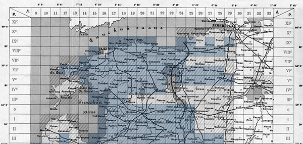
Index sheet of set “Двухверстная карта западного пограничного пространства“ (Map of west borderland, scale 2 verst per inch/1:84000), north zone (Estonia, Latvia, west borrders of Russia), in green color-diditalized maps
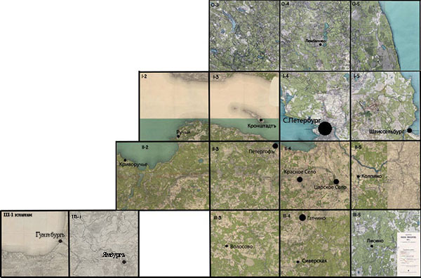
Index sheet of maps in scale 1:84000 showing Sankt Petersburg surroundings; maps prepared using 1890-95 survey. It is interesting, that maps printed in 4 colors: woods shown in green, waters in blue, railways in red, other content in black. Relief shown by shading. On map III-5 shown legend with name of map "Map of area of exercises 1913"
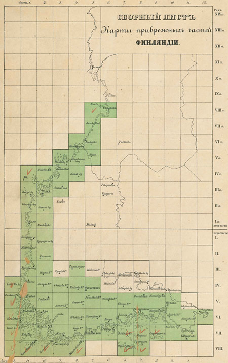
Territories of Finland (coast and islands) were covered by maps from set "Map of inshore part of Finland" (in original [RU] "Карта прибрежных частей Финляндии"). Set was prepared in 1855-1856 by topographers of Russian empire under leadership of colonel Gustaf Adolf Kalmberg. Scale of map 1:84000. Set consists of several maps, each map was named by Roman digits (showing Row) and Arabic digits (showing position in row). Example Ряд VIII Лист 12. Content in maps shown by signs, simbols and by colors. All content in map shown in black, woods in green. Relief on maps is nor shown. Index of this maps (link).
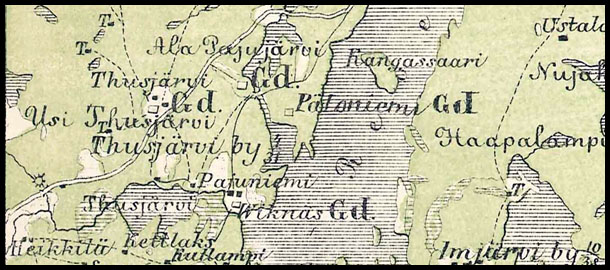
As example - fragment of "Map of inshore part of Finland" (in original "Карта прибрежных частей Финляндии", 1855-1856, 1:84000)
|
| Updated 10 August 2014 www.maps4u.lt © |
|
|
Map XII-18
Map XII-18 from set Two-verst map (1:84000) of west borderland of Russian Empire (Full size view).
All available maps are marked in blue (see index sheet).

General view of Two-verst map (1:84000) of west borderland of Russian Empire, sheet XII-18
|
|


