|
Index of German II WW maps in scale 1:100000
German topographers produced in 1940-1945 large-format maps (each map consists of 4 basic maps) in scale 1:100000. Maps of this collection fully or partially cover the territory of Poland, Lithuania, Latvia, Byelorussia and East Prussia. The basic materials for these maps were: Map of Germany in scale 1:100000, maps from the collection of Karte des westlichen Russlands in scale 1:100000, Polish WIG maps in scale 1:100000, Latvian maps in scale 1:75000, Lithuanian maps in scale 1:100000.
Full list (including year publishing) of Grossblatts which cowering Lithuania and neighbor territories you can find THERE.
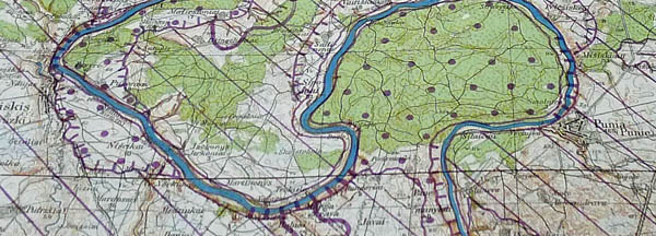
Fragment of German map in scale 1:100000 (Grossblatt 1 memel, 1944)
Using basic maps in scale 1:100000 German topographers prepared and published Geological map of east territories (original named Wehrgeologische Stellungsbaukarte Ost, publisher Gen. Staff of German army). Maps from this set covered territories of west Lithuania and part Poland also (see index sheet below).
Index sheet of Geological map of east territories (original named Wehrgeologische Stellungsbaukarte Ost, 1:100000, east part of index)
Fragment of Geological map of east territories, sheet Nr. 327 Maryampol
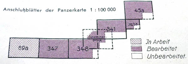
Using basic maps in scale 1:100000 set Panzerkarte (in EN Tank maps) was released. Maps from this set (scale 1:100000) covered only territories of Poland (see index sheet below). On maps was marked areas where using tanks was encumbered (impossible).
Index of set Panzerkarte (Poland, 1:100000)
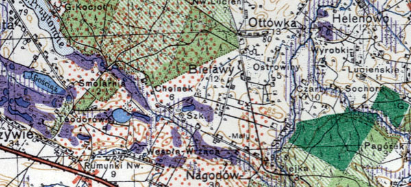
Fragment of map from set Panzerkarte (Nr.347, Poland, 1:100000, map photographed)
|
|
Ostland 1:100000, Russland 1:100000.
During Second World war German army published maps in scale 1:100000 in frames of collection Ostland 1:100000. These maps cover territories of Estonia, Latvia, Lithuania and west Byelorussia. Maps from collection Ostland 1:100000 were published using original Estonian, Latvian, Lithuanian maps in scale 1:25000, 1:50000, 1:100000, 1:200000 and RKKA maps in scale 1:50000, 1:100000. Maps were recognized using aero photographing.
Maps from collection Ostland 1:100000 have frame with dimensions 20′ latitude and 30′ longitude. Longitude was considered from Greenwich. Maps were published in color.
List of available German maps from sets Ostland 1:100000 and Russland 1:100000 you can find THERE.
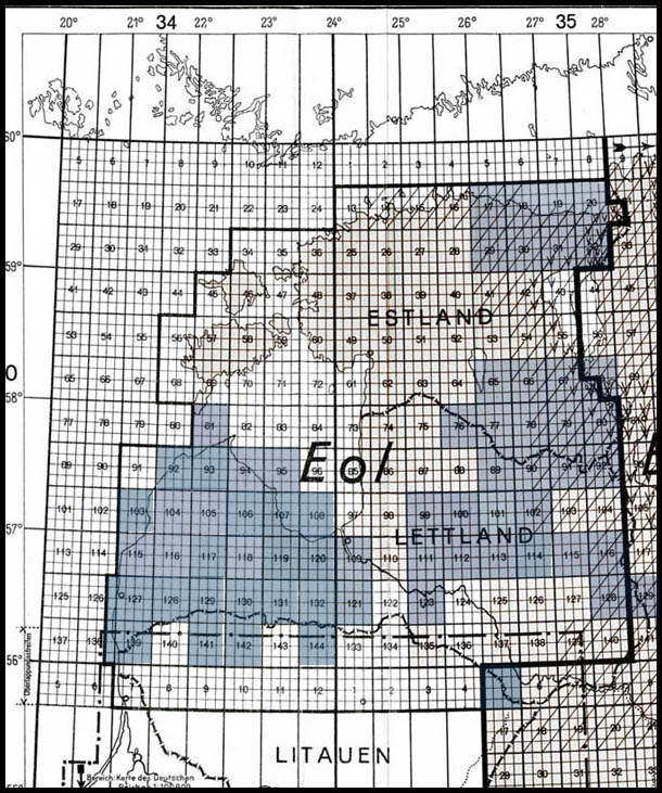
Index sheet of German maps from set Ostland 1:100000 (available maps are marked in blue).
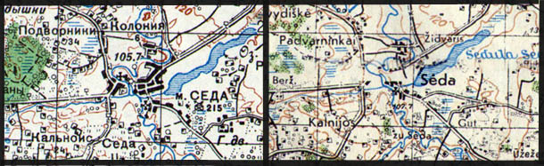
Fragment of German map O-34-141 (1944) and soviet RKKA map O-34-141 (1938) on city Seda (Lithuania). On German map all place-names in Lithuanian (Latin alphabet), on RKKA map all place-names in Russian (Cyrillic).
Most German maps from set Ostland 1:100000 are updated using aeronautical photographing (1939). Place-names are prepared by Language study institute in Vilnius (Lithuania). Basis of maps from set Ostland 1:100000 - Latvian maps in scale 1:75000, 1:200000, Lithuanian maps in scale 1:100000, RKKA maps in scale 1:50000, 1:100000.
(Last updates 2010 10 21)
|
|
German maps in scale 1:100000 from collection "Estland-lettland 1:100000 (index sheet), link
During II World War German cartographers, using available maps, especially Estonian and Latvian maps in scale 1:200000 (link1, link2), produced maps in scale 1:100000 on the territory of Estonia and Latvia. These maps were available in the collection of maps "Estland Lettland 1:100000".
Also observed maps from set "Estland Lettland 1:100000" based on Latvian maps in scale 1:75000.
Maps have size - 30' latitude and 45' longitude, witch is considered from Greenwich.
Maps from collection "Estland Lettland 1:100000" are numbered (see index sheet) by two numeral number, two letters with number (NO, NW, SO, SW), indicating the position of maps in square and name of the largest municipality in map.

General view of map 43 NW Riga from set "Estland Lettland 1:100000" (1940, 1:100000)

Fragment of map 43 NW Riga from set "Estland Lettland 1:100000" (1940, 1:100000)
|
|