|
Deutsches Reich 1:25000 (4 cm Karte)
During II WW part of Poland was transferred to Germany (Deutsches Reich) province East Prussia. Messtischblatts in scale 1:25000 covered territories of Germany till II WW. New maps (new series) were prepared to new annexed territories. Messtischblatts were produced also to annexed territories which were transferred to "old-named" provinces. Like so, we can find Messtischblatts which are covering territories of Lithuania, Belarus and east Poland. They are prepared using half (one) verst maps of czarist Russia empire, sometimes-Polish WIG maps in scale 1:25000. Parallel with Messtischblatts on territories former Poland (which were transferred to Germany /Deutsches Reich) was published set maps in scale 1:25000 "Deutsches Reich 1:25000 (4 cm Karte)". Maps has size 1/4 of German "Karte des Deutschen Reiches" map in scale 1:100000 or Polish map WIG in scale 1:100000. Maps from this set have dimension 7,5 minutes of latitude and 15 minutes of longitude. Maps were named according in correspondence of German "Karte des Deutschen Reiches" map in scale 1:100000 or Polish map WIG in scale 1:100000 indicating one-quarter which shows maps from set "Deutsches Reich 1:25000 (4 cm Karte)". (Example 3135/4 or 78/4) Parallel maps were named by biggest population place (in accordance whit maps in scale 1:100000) indicating one-quarter by abb. NO, NW, SO, SW (example Birkenmuhle SO). If both maps- German "Karte des Deutschen Reiches" map in scale 1:100000 and Polish map WIG in scale 1:100000 were published, maps from set "Deutsches Reich 1:25000 (4 cm Karte)" has combined name (example Birkenmuhle SO - 78/4 (3135/4). Maps were printed in one color.
On frames was given additional information: which maps were used to prepare map, administrative partition, arbitrary signs and symbols (to all kind maps which were used), abbreviations, organizer, publisher and other information.
In collection we have only one map from this set:
Birkenmuhle SO - 78/4 (3135/4), published in 1941. 5
|
|
UdSSR 1:25000 (4 cm Karte)
Territories in east of Germany (Deutsches Reich) and General region (General Gouvernement), which till II WW belonged to Soviet Union (partially till 1939 to Poland), were covered by maps in scale 1:25000 from set "UdSSR 1:25000 (4 cm Karte)". Maps has size 1/4 of Polish map WIG in scale 1:100000 (or 7,5 minutes of latitude and 15 minutes of longitude). Maps from this set are prepared using Polish WIG maps in scale 1:25000 or WIG 1:100000 (were maps in scale 1:25000 were not prepared). Maps from set "UdSSR 1:25000 (4 cm Karte)" were named according in correspondence of Polish map WIG in scale 1:100000 indicating one-quarter which shows maps from set "UdSSR 1:25000 (4 cm Karte)" (example 2940/1). Parallel maps were named by biggest population place (in accordance whit maps in scale 1:100000) indicating one-quarter by abb. NO, NW, SO, SW (example Majszagola NW). Example: Full name of this map would be: Mejszagola NW - 2940/1.
Maps were printed in one color.
On frames was given additional information: which maps were used to prepare map, administrative partition, arbitrary signs and symbols (to all kind maps which were used), abbreviations, organizer, publisher and other information.
In collection we have these joined maps from set "UdSSR 1:25000 (4 cm Karte)":
2940/1 Mejszagola NW,
2940/2 Mejszagola NO,
2940/3 Mejszagola SW,
2940/4 Mejszagola SO,
2941/1 Niemenczyn NW,
2941/2 Niemenczyn NO,
2941/3 Niemenczyn SW,
2941/4 Niemenczyn SO,
3040/1 Wilno NW,
3040/3 Wilno SW,
3040/4 Wilno SO,
3041/1 Nowa-Wilejka NW,
3041/2 Nowa-Wilejka NO,
3041/3 Nowa-Wilejka SW,
3041/4 Nowa-Wilejka SO,
3338/3 Porzecze SW,
5041/4 Tarnopol SO.
|
|
Generalgouvernement 1:25000 (4 cm Karte)
Territories of General region (General Gouvernement), which consisted of former Galicija, Krakow, Radom, Lublin, Warszawa departments, were covered by maps in scale 1:25000 from set "Generalgouvernement 1:25000 (4 cm Karte)". Maps has size 1/4 of Polish map WIG in scale 1:100000 (or 7,5 minutes of latitude and 15 minutes of longitude). Maps from this set are prepared using Polish WIG maps in scale 1:25000 or WIG 1:100000 (were maps in scale 1:25000 were not prepared). Maps from set "Generalgouvernement 1:25000 (4 cm Karte)" were named according in correspondence of Polish map WIG in scale 1:100000 indicating one-quarter which shows maps from set "Generalgouvernement 1:25000 (4 cm Karte)" (example 4538/4). Parallel maps were named by biggest population place (in accordance whit maps in scale 1:100000) indicating one-quarter by abb. NO, NW, SO, SW (Wlodzimierz SO). Example: Full name of this map would be: Wlodzimierz SO - 4538/4.
In parallel with maps which have dimensions as mentioned above it was prepared and published maps in set Generalgouvernement 1:250000 (4 cm karte) which have dimensions as Polish WIH 1:25000 maps - 5 minutes of latitude and 10 minutes of longitude. These maps were named like Polish WIG 1:25000 maps XX/YY-A (B, C, D, E, F, G, H, J), additionally the biggest name of popilated places on map was given (egz.: 47/29 C Chlina)
Maps were printed in one color.
On frames was given additional information: which maps were used to prepare map, administrative partition, arbitrary signs and symbols (to all kind maps which were used), abbreviations, organizer, publisher and other information.
In collection we have these joined maps from set "Generalgouvernement 1:25000 (4 cm Karte)":
Wlodzimierz SO - 4538/4, 1942. 8.
Lezajzk SW - 4735/3, 1941. 6.
47/29 C Chlina, 1944.
47/29 F Wolbrom, 1944.
|
|
1:25000 Dunaabschnitt
In 1941 German topographers published set maps in scale 1:25000 on territory of Latvia (valley of river Daugava) Dunaabschnitt 1:25000. Numbering of maps from this set is peculiar; maps from set were named by four numbers and name of biggest populated place in sheet. Maps from set Dunaabschnitt 1:25000 are prepared using German I WW maps Rusische Karte des westlichen Grenzgebiets. Maps were updated according information from aero photographing. Place-Names in maps was written in Latvian.
Maps from set Dunaabschnitt 1:25000 have dimensions-5 minutes of latitude and 9 minutes of longitude. Value of longitude and latitude on sheets are not given; inscribed kilometer's net.
On frames was given additional information: name of map, number of series, which maps were used to prepare map, date and area of aero photographing, date of publishing, organizer, publisher and other information.
Maps were printed in tree colors: river Daugava in blue, updates in red, all other content in black.
In collection we have only one map from this set: 0710 Lielvardes.
|
|
Ostland 1:25000
Although province of Ostland (Reichskommissariat Ostland) in a broad sense covered territories of Estonia, Latvia, Lithuania, and west Belorussia, maps from set Ostland were published on territories of Estonia, Latvia and north Lithuania. On territories of east Estonia, east Latvia, east Lithuania, Belarussia were set of maps Russland (also see set of maps UdSSR 1:25000). Rest of Lithuania territory was covered by maps from German (Deutsches Reich) maps collections (also see Messtischblatts, UdSSR 1:25000, Dubysaabschnitt 1:25000 sets). RKKA till II WW published maps in scale 1:25000, which partially covered also Lithuania (border between Germany and Lithuania, surroundings Kaunas). Estonian, Latvian topographers in years 1920-1940 also were prepared and published maps in scale 1:25000. German topographers republished these maps making (or without changes) some adjustments acc. aero photographing, newest cartographical material.
Standard maps from set Ostland 1:25000 have dimension 5 minutes of latitude and 7 minutes of longitude. It was combined of 2 or 4 sheets maps (Zusammendruck).
Maps from set Ostland 1:25000 were published in coloring as original (or in one color).
On frames was given: number of map, tipe of map (Behelfsausgabe, Sonderausgabe...), series, which maps were used to prepare map, date and area of aero photographing, date of publishing, organizer, publisher and other information.
List of maps from collection Ostland 1:25000 you can find THERE.
|
|
Russland 1:25000
II WW maps from collection Russland 1:25000 covered territories of east Estonia, Latvia, Lithuania, big part of Bielorussia (also see Messtischblatts, UdSSR 1:25000 series), Russia. Most of maps from collection Russland 1:25000 were prepared according RKKA 1:25000 maps or RKKA 1:50000 (by enlarging) frequently using aero photographing.
Standard maps from set Russland 1:25000 have dimension 5 minutes of latitude and 7 minutes of longitude. It was combined of 2 or 4 sheets maps (Zusammendruck).
Maps from set Russland 1:25000 were published in coloring as original (or in one color).
On frames was given: number of map, tipe of map (Behelfsausgabe, Sonderausgabe, Stellungskarte..), series, which maps were used to prepare map, date and area of aero photographing, date of publishing, organizer, publisher and other information.
List of maps from collection Russland 1:25000 you can find THERE.
In collection we have maps from set Russland 1:25000 prepared according RKKA maps in scale 1:50000 (by enlarging), which has dimension 2 minutes of latitude and 6 minutes of longitude (type of map- Stellungskarte). These maps have numbering A-XX-YY- (1-20) (example N-36-98-15).
I collection we have three maps N-36-98-4, N-36-98-10, N-36-98-14 (published in 1943).
|
|
1:25000 Dubysaabschnitt (Index sheet)
1:25000 Dubysaabschnitt
In 1941 German topographers published set maps in scale 1:25000 on territory of Lithuania (valley of river Dubysa) Dubysaabschnitt 1:25000. Maps from set Dubysaabschnitt 1:25000 are prepared using German I WW maps Rusische Karte des westlichen Grenzgebiets. Maps were updated according information from aero photographing. Place-Names in maps was written in Cyrillic and Latin letters (some place-names in Lithuanian). Maps from set "Dubysaabschnitt 1:25000" were named according in correspondence of maps from set Rusische Karte des westlichen Grenzgebiets additionally each sheet of map was named by of biggest populated place in sheet.
Maps from set Dubysaabschnitt 1:25000 have dimensions-5 minutes of latitude and 9 minutes of longitude. Value of longitude and latitude on sheets are not given; inscribed kilometer's net.
On frames was given additional information: name of map, number of series, which maps were used to prepare map, date and area of aero photographing, date of publishing, organizer, publisher and other information.
Maps were printed in one color.
Digitalized maps from this collection in index sheet are marked in blue.
|
|
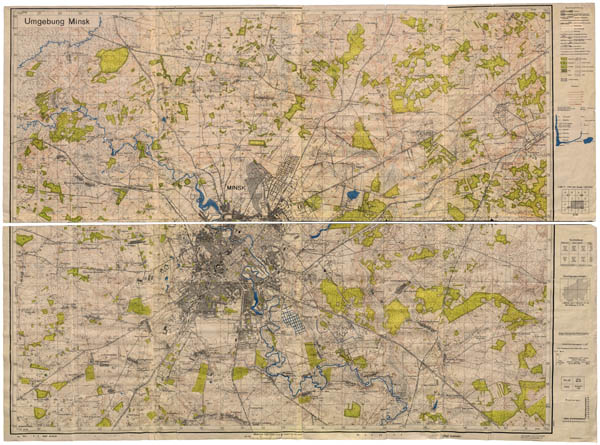
German map of Minsk (Capital of Belorus) district in scale 1:25000, 1944
German map of Minsk (Capital of Belarus) district (in German - Umgebung Minsk) in scale 1:25000. This map was prepared using RKKA maps in scale 1:25000 (published in 1933), recognizing according air picture from 1942-1943. Color map of Minsk district published in 1944.
|
|
II WW period German maps in scale 1:25000 on territories of central Lithuania
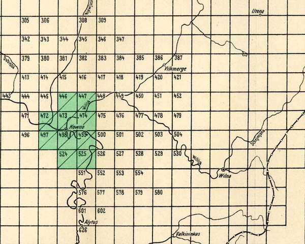
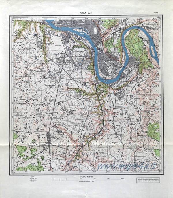
Besides II WW period German maps on territories of Lithuania from sets Messtischblatt, UdSSR 1:25000 (4 cm Karte), 1:25000 Dunaabschnitt, (Ostland 1:25000?) were prepared and published maps on territories of central Lithuania. Maps from this set were prepared using inter-war Lithuanian maps in scale 1:25000. Republished maps had the same size as Lithuanian maps, content was the same, but were some upgrades in road net, German kilometer-net was drawn in maps. Name of sheets were translated in German.
As shown in index sheet it was published at least 10 maps from set on territories of central Lithuania. Below you can see the big picture of map from this set named 498 Kauen Sud.
Literature: Planheft Osteuropa Baltischer raum 1944, ...Vademecum Ost 1940, Plancheft Ubersichten Ost 1941.
|
|
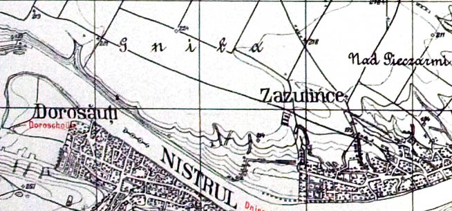
German II WW maps in scale 1:25000 covering Bessarabia (Moldova now), index sheet (link).
During II WW German topographers using Romanian maps in scale 1:20000, 1:100000 prepared set of maps in scale 1:25000 on territories of Bessarabia (+- Moldova now). Set consists of more than 500 maps. Maps were printed in one colour, water on some of maps from this set was coloured in blue, some changes in road net, transcription of names, boundaries of administrative units were signalized in red colour. On margins additional information such signs, simbols, name of neighbouring sheets was given. Name of maps consists of 4 digit number and name of biggest population place. Fragment of map 4190 Mitsâu, 1:25000, 1941.
|
|
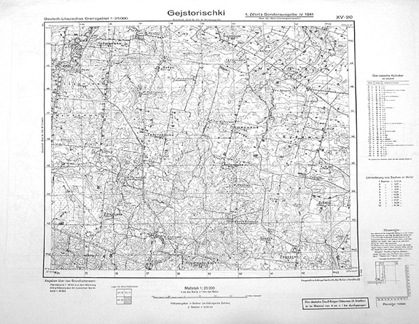
Index sheet of maps‘ set Deutsch-Litauisches Grenzgebiet (Germany-Lithuania border line) in scale 1:2500, WWII (link)
In April-Mai 1941 German topographers prepared and published set from 73 maps on border territories of Lithuania named Deutsch-Litauisches Grenzgebiet 1:25000 (Germany-Lithuania border line 1:25000).
Maps named: first Roman digit (II-XV) shows column, second Arabian digit (20-38) shows row, additionally by name of biggest population place on map. Example of name: XV-20 Gejstorischki
All maps from set Deutsch-Litauisches Grenzgebiet 1:25000 (Germany-Lithuania border line 1:25000) prepared using old cartographic material: territory of Lithuania from set Russischen karte des Westlichen Grenzgebiets 1:25000, territory of Germany from newest Messtischblatts (TK25). Content on maps was not updated, only place names parallel were translated and given in German transcription.
Size of maps 5′ latitude x 9,00,48′ longitude. Longitude was calculated from Greenwich.
On margins additional information was given: name of set, name of map, dates of preparing and publishing, publisher, names and scheme of neighboring maps, scale, information about primary cartographic material, translating Cyrillic letters to German, translating fathoms into meters, other information. Additional on maps was Gauss-Kruger net drawn (8 zone).
General view map XV-20 Gejstorischki from set Deutsch-Litauisches Grenzgebiet 1:25000 (Germany-Lithuania border line 1:25000), 1941
|
|