|
Soviet maps in scale 1:100000 (1 cm-1 km.). Index sheet on the territory of Lithuania
Maps in scale 1:100000 (1 km - 1 cm) are formed by dividing 1:1000000 map into 144 parts. Nomenclature of maps in scale 1:100000 consists of leaf designation 1:1000000 scale map with the addition of one of the numbers 1, 2, 3, 4 , 5, ..., 143, 144 and name of biggest population place in map. To avoid confusion with the maps in scale 1:500000 and 1:200000 (for which there are alternative similar designation), maps of this scale may be referred to three-digit Arabic numerals without losing leading zero’s, for example: N-35-010. Parallel maps in scale 1:100000 are named by only digits: example 14-35-010. All content in maps in Cyrillic. On margins of maps (scale 1:100000, the coordinate system in 1942) are presented: the map name, the compiler and publisher of maps, adm. division, date of creation and printing, magnetic declination, some abbreviations and symbols, scale and basic cartographic material used for creating maps.Size maps in scale 1:100000 (1cm.-1km.) -20' latitude x 30' longitude. Relief displayed every 20 m. in horizontals.The first post-war edition of maps in scale 1:100000 on the territory of Lithuania was published in 1951-1954, the territory of Lithuania display 78 maps in scale 1:100000 (1942 cc). every 6-12 years maps in scale 1:100000 were updated and reprinted. The latest edition - 1983-1989. When the coordinate system 1963 y. was established, S1:100000 maps were transferred to this system (starting in 1964-1965). Released 2 full and 1 partial publication of maps in scale 1:100000 in the coordinate system in 1963 on the territory of Lithuania (the last partial edition 1981-1985). On the maps in coordinate system 1963 y. not listed coordinates, displayed only the territory of the USSR.More about maps coordinate system 1963 THERE (link).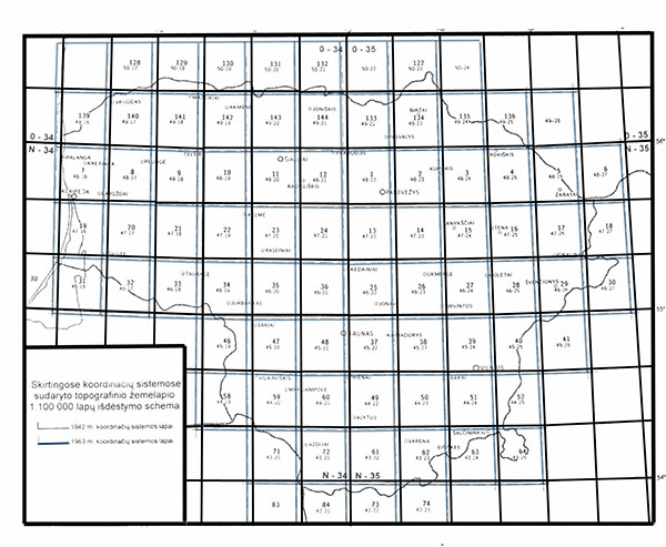 Index of soviet 1:100000 maps on territoty of Lithuania (1942 y. c.s. and 1963 y. c.s.). Full size (link) Index of soviet 1:100000 maps on territoty of Lithuania (1942 y. c.s. and 1963 y. c.s.). Full size (link)
 As example soviet map in scale 1:100000 (1cm.-1km., 1942 y. c.s.) map N-34-007 Клайпеда, 1986 (Full size, link) As example soviet map in scale 1:100000 (1cm.-1km., 1942 y. c.s.) map N-34-007 Клайпеда, 1986 (Full size, link)
 As example soviet map in scale 1:100000 (1cm.-1 km., 1963 y. c.c.s.) map C-48-16, 1977 (full size, link) As example soviet map in scale 1:100000 (1cm.-1 km., 1963 y. c.c.s.) map C-48-16, 1977 (full size, link)
|
|


