Maps showing territories of parceling (dividing) estates, subdividing villages to granges in Lithuania at period 1919-1939.
Maps showing territories of parceling (dividing) estates, subdividing villages to granges in Lithuania at period 1919-1939. Maps were based on German maps in scale 1:100000 named "Karte des Westlichen Russlands". We found these maps in private collection. Maps were photographed till II WW, negatives were made on glass plates (dimensions 6x8 cm.), condition of negatives now are mean... Part maps (originals) showing parceling estates were found in archive. Still are missed 2 maps - O19 and P20.
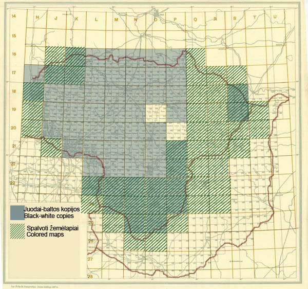
Index sheet showing digitalized maps (based on maps from German maps set "Karte des Westlichen Russlands" of parceling (dividing) estates, subdividing villages to granges in Lithuania at period 1919-1939. Digitalized maps marked in blue (b.w. scans) and in green (colored maps).

Fragment of original (not photographed) map of parceling (dividing) estates, subdividing villages to granges in Lithuania at period 1919-1939. Map based on German map M24 Kalwarija from set "Karte des Westlichen Russland". Fragment of map shows dividing of estates Kalvarija, Orija, Janavas...

Fragment of original map of parceling (dividing) estates to granges in Lithuania at period 1919-1939. Map based on German map M24 Kalwarija from set "Karte des Westlichen Russland". Fragment of map shows dividing of estates Grabauka, Dotamai (on map Detomiszki, Grabowka, in 1922 these esates were at district Vilkaviškis, administrative unit Bartininkai).
By parceling estates new small territories (mostly 4-8 ha) were released to new owners (landless peasants, volunteers, soldiers). Process of parceling of estates started practically after First World War and continued till 1940. It was parceled more than 1000 estates in Lithuania. For each paceled estate was plan of parceling made. Mostly plans were in scale 1:5000 (size about 2x1 m.). On plans usually was explication where all new owners were listed, all new territories were drawn, landed by coloring was shown also. As example estate Grabauka (Grabowka in Polish) in 1922 was divided into more than 40 parts. New owners were:
Pijus Jašinskas, Jonas Lukoševičius, Jonas Savickas, Juozas Zinkevičius, Jonas Petrulis, Jurgis Navikas, Juozas Četvertinskas, Jonas Kerevičius, Vincas Rožaitis, Jonas Ališauskas, Motiejus Ališauskas, Vincas Razumauskas, Antanas Blauzdžiūnas, Mikas Živilas, Jonas Mečeckas, Kazys Eidukevičius, Jokimas Pakulis, Jonas Balanda, Andrius Eidukevičius, Petras Glaveckas, Petras Venclova, Juozas Kerevičius, Pijušas Mikolaitis, Pijušas Navickas, Andrius Čereška, Ona Rožaitienė, Cicilija Šitkauskienė, Juozas Andriuškevičius, Jonas Mikalauskas, Kazys Mykolaitis, Juozas Bagdonas, Uršulė Mackevičaitė, Jonas Griškaitis, Tomas Birštonas, Agota Ligmalienė, Jonas Pakulis, Jonas Zajenkauskas, Juozas Navickas, Kazys Abraitis (?), Jonas Kavaliauskas, Kazys Kotkė.

Plan showing parceling of estate Grabowka (Grabauka) in 1922, 1:5000. As result village Skroblai was created (Grab in Polish and Skroblas in Lithuanian - Hornbeam).

One new owner Pijušas Mikolaitis with daughter and her infants


