|
|
|
Other (single, period 1940-1945/Second World War) German maps showing Lithuania
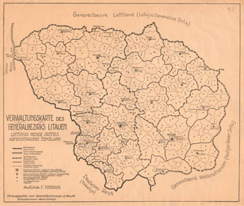 |
Administrative map of area of (Verwaltungskarte des generalbezirks Litauen, Lietuvos generalinės srities administracinis žemėlapis). Scale 1:1000000, 1941-1944.
Full map (link).
|
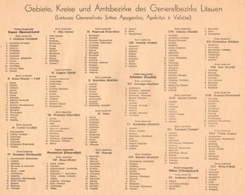 |
Revers of administrative map of area of (Verwaltungskarte des generalbezirks Litauen, Lietuvos generalinės srities administracinis žemėlapis). List of units and subunits.
(link, full size).
|
|
|
German operational maps from period WWII
German operational maps from period WWII showing position of units on certain time at cetrtain positions. Usually operational maps show situation on whole front (fronts) or on all batle (conflict) line.
We are presenting operational maps prepared by German topographers during WWII (scale mostly 1:1000000). Maps show situation on begining of WWII - June and July 1941.
| Name |
Size and link |
Remarks |
| Maps showing postions of units on June 1941. |
247 MB |
1941.06.16
1941.06.19
1941.06.23
1941.06.24
1941.06.25
1941.06.26
1941.06.27
1941.06.28
1941.06.29
1941.06.30 |
| Maps showing postions of units on July 1941. |
135 MB |
1941.07.01
1941.07.02
1941.07.03
1941.07.05
1941.07.06
1941.07.07
1941.07.09
1941.07.10
1941.07.11
1941.07.12
1941.07.15 |
Keywords: Lage ost, operational maps.
|
|
Map of roads of Baltic States, 1941
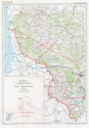
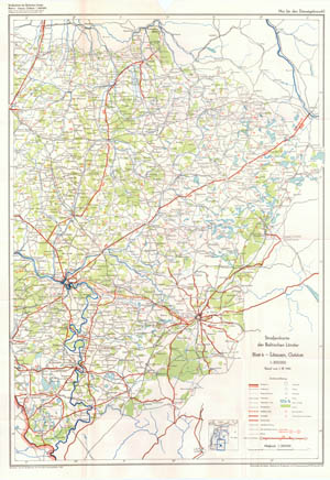
German topographers (publisher Generalstab des Heeres, Abteilung für Kriegskarten und Vermessungswesen) in 1941 published set of maps of roads of Baltic States (Estonia, Latvia, Lithuania). Original name of set - Strassenkarte der Baltischen Länder, scale - 1:300000. Maps prepared using original maps of roads published in each country. Situation - beginning of 1941 y. Set Strassenkarte der Baltischen Länder consists of 6 maps: 1-2 map shows roads of Estonia, 3-4 - Latvia, 5-6 Lithuania. Preparing 5-6 maps (Roads of Lithuania) was use map of roads of Lithuania (1939) - Lietuvos kelių žemėlapis (Carte Routiere de Lithuanie). Maps coloured: water in blue, woods in green, main roads and boundaries in red, other content in black. Size of maps 97x68 cm. Below - general view of 5, 6 maps from set Strassenkarte der Baltischen Länder (territory of Lithuania).
|
|
|
|
Not a member yet? Click here to register.
Forgotten your password? Request a new one here.
|
|