|
Index sheet of Latvian maps in scale 1:25000
Latvian maps in scale 1:25000 were released by Geodesic - Topographic Division of headquarter of Latvian army (Armijas Štāba Ģeodēzijas Topogrāfijas dala). These maps were produced by the Russian Empire maps in scale 1:42000 (1:21000), part of their updating. Maps in scale 1:25000 have trapezoid shape, the size of the frame were 10' longitude and 5' latitude. Longitude from Greenwich is considered.
In collection we have 92 maps in scale 1:25000.
|
|
Index sheet of Latvian maps in scale 1:75000
Latvian maps in scale 1:75000 were in years 1924-1924 published by Geodesic - Topographic Division of headquarter of Latvian army ( Armijas Štāba Ģeodēzijas Topogrāfijas dala). These maps were produced by the Russian Empire maps in scale 1:84000 ( Двухверстная карта западного пограничного пространства), part of their updating. Maps in scale 1:75000 have trapezoid shape, the size of the frame were 30' longitude and 15' latitude. Longitude from Greenwich is considered.
|
|
Index sheet of Latvian maps in scale 1:200000.
Latvian maps in scale 1:200000 were published by Geodesic - Topographic Division of headquarter of Latvian army (Armijas Štāba Ģeodēzijas Topogrāfijas dala). Publishing was agreed on a framework and the names of populated places with the General Staff of the Estonia Army. Estonia produced similar collection maps in scale 1:200000.
Maps in scale 1:200000 have trapezoid shape, the size of frame 1 deg.30' longitude and 1deg. latitude. One map in scale 1:200000 covers the 12 maps in scale 1:75000. Longitude from Greenwich is considered.
Collection consists of 12 maps in scale 1:200000.
|
|
Example of maps in scale 1:75000 and 1:25000.
Example of maps in scale 1:75000 (68 Jakabpils) and 1:25000 (68-c).
|
|
Index sheet of Latvian maps in scale 1:50000.
Latvian maps in scale 1:50000 were published by Geodesic - Topographic Division of headquarter of Latvian army (Armijas Štāba Ģeodēzijas Topogrāfijas dala). These maps were produced using Russian Empire maps. It was planed to publish 285 maps, but only about 45 maps in scale 1:50000 was released. Published maps covered territories near Riga (capital of Latvia), city Cesis and north-east part of Latvia. Maps in scale 1:50000 have trapezoid shape, the size of the frame were 15' longitude and 10' latitude. Longitude from Pulkovo is considered. All elements of maps in scale 1:50000 were printed in black, only kilo-metrical grid in red (on some maps water printed in blue).
|
|
Latvian maps in scale 1:400000
Latvian map in scale 1:400000 named "Latvijas Karte" was published by Geodesic - Topographic Division of headquarter of Latvian army (Armijas Štāba Ģeodēzijas Topogrāfijas dala) in 1930. Map consists of 2 sheets, each has dimension 85x65 cm. Maps were printed in color: boundaries abd main roads in red, water in blue, forests in green, relief in braun, other content in black. Relief was shown by horizontals every 20 meters. Longitude from Greenwich is considered.
|
|
Example of Latvian (1918-1940) maps in scale 1:50000
Example of Latvian (1918-1940) maps in scale 1:50000: map Nr.193 Madona (1925 y.).
|
|
Single Latvian inter-war maps
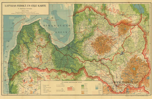 |
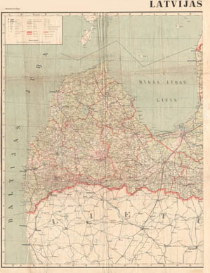
| Physical Map of Latvia with roads (Latvijas Fiziska un cielu karte), prepared by T.Hartman, publisher cartographic institute of Ošins and Mantnieks 1930. Scale 1:700000. Enlarge (link) |
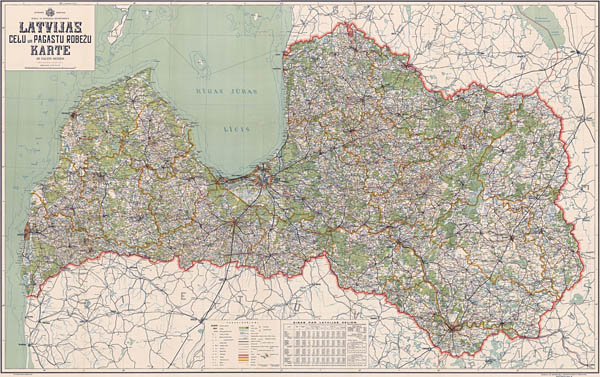 |
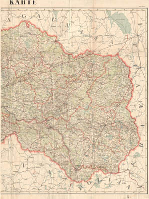
| Map of Latvia (roads and administrative districts) (Latvijas celu un pagastu robežu karte), scale 1:300000, 1934. Full size (link). |
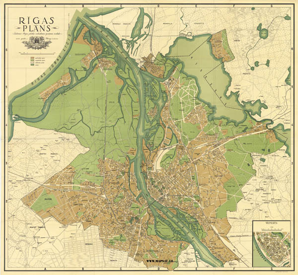 |
| Plan of city Riga (Rigas plans), scale 1:25000, 1933. FULL SIZE (LINK). |
Map of Latvia railways, about 1920, 1:665000, creator B.Jauncems,
Map of Latvia railways, 1920, 1:2000000,
Map of Latvia railways, 1924, 1:600000,
Map of Latvia railways 1925,
Map of Latvia railways, 1926, 1:600000, publisher ARGUS,
Map of Latvia railways, 1928, 1:600000,
Map of Latvia railways, 1929, 1:600000,
Map of Latvia railways, 1931, 1:600000, publisher ARGUS,
Map of Latvia railways, 1933,
Map of Latvia railways, 1937,
Map of Latvia railways, 1939, 1:600000.
Map of Latvia roads, about 1930, 1:1400000,
Map of Latvia roads, 1930, 1:500000,
Map of Latvia roads (and administrative units), 1931, 1:300000,
Map of Latvia roads, 1935, 1:1000000,
Map of Latvia roads, about 1940-41, 1:400000.
|
|
|
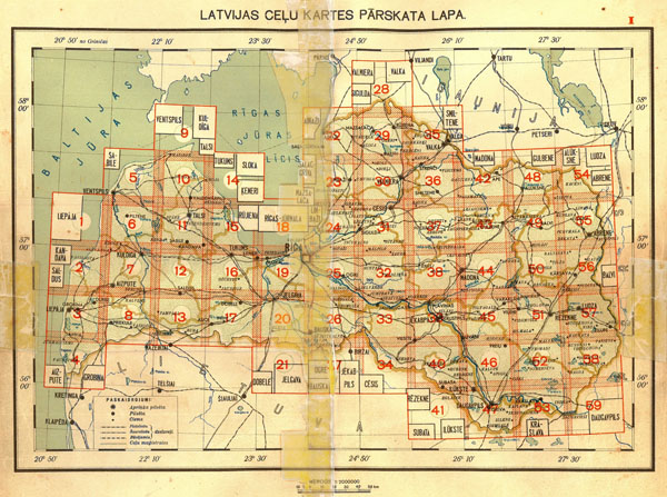
Latvia Road map (Latvijas celu karte), 1:200000, 1940
Latvia road map (in original Latvijas celu karte) was prepared and published by department of roads and highways (Soseju un zemescelu departaments) in 1940. Map consists from 20 sheets of text and 65 maps. Size 25,8x 14,2 cm, sheets and maps were bind to brochure.
Index of Latvia road map, 1:200000, 1940.
Latvia Road map shows only territory of Latvia, territories of neihgbouring countries showed schematically - showed only biggest populated places and roads. On some maps plans of biggest Latvia cities are showed. On separates sheets signs and symbols, roads signs, shema of numbering of roads are published. By special signs and symbols on Latvia road map populated places, net of roads and railways, woods, hydrography, other content are showed. Relief was not shown.
Latvia Road map published in 1940 was regularly used by German topographers to prepare German maps (to revise names of populated places).
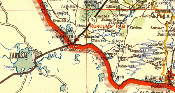
Fragment of Latvia road map, map Number 47 showing border between Latvia and Lithuania, 1:200000, 1940.
|
|