|
|
|
RUSSIAN MAPS (1790-1917) - Russian Imperia at 1917. |
|
|
Russia Imperia at 1800.
Russian Empire in ca. 1800 European Part. After the third dividing of Zhechpospolita (1795) mapping of Lithuania, the majority ensnared in the Russian Empire, was granted to the civil institutions of Empire. In 1799 a decree was decided to measure the main roads, state postal station, in 1803 issued instructions specified objects to be marked in prepared the atlas. At the beginning of the XIX century it was began half-instrumental topographical picture of territory of Lithuania (in consist of Russian Imperia). Before the 1812 military topography empire maps were only on the frontiers of the empire
|
|
Russian Imperia at 1818
Russian Imperia at 1818. Carte de la partie europeenne de l'empire de Russie.1818.
Systematic, based on geodetic points, topographical works in the territory of Lithuania for the first time took place in the years 1819-1830. It was based on the triangulation network which was still unfinished. This work led by F. Schubert, K. Tenner. Topographical picture of Vilnius Province was in scale 1:21000 (later picture was taken in scale 1:42000 ). This topographical picture was used producing tree-verst (1:126000) maps (from 1845 *), ten-verst (1:420000) maps (1821-39, 1865-1917), five-verst (1:210000) maps.
|
|
Russian Imperia at 1917.
C.S.Hammond. Russia in Europe. 1918. In the second half of XIX century maps, which were made on the results of the first topographical picture, were not in accordance with the requirements of military and civilian agencies. It was decided to do a new survey. From 1882 (until 1907) in Lithuania, it was made instrumental picture in scale of 1:21000. Originals of this were used by making a map scale of 1:42000. Based on the survey was released the most popular among the military map of scale 1:84000. On sheme (see below) you can see period when 0,5-verst syrvey (1:21000) in Lithuania was released.
|
|
Lithuania on maps based on 0,5-verst survey of Russian empire (period 1880-1917), link to index.
Using 0,5-verst survey of Russian Empire topographers of Russian empire, Germany (also Poland, Lithuania...) published series map on territories Lithuania. At scheme (see below or link above) you can see territories of Lithuania that covered by maps based on 0,5-verst survey of Russian empire (maps4u.lt collection). At scheme also shown German maps (in green), Messtischblatts (TK25) that cover part of present west Lithuania (original German Survey, 1910-1914 or republished in 1940-1945).
In blue shown 0,5-verst or 1-verst maps of Russian Empire
Ir red shown German maps from period WWI (based on 1-verst maps of Russian Empire) - Russische karte des westlichen grezgebiets (scale 1:25000).

On this scheme you can discover how cover territories of Lithuania 1-verst and 2-verst maps of Russian Empire (each 2-verst map consists of 9 0,5-verst maps, each 1-verst map consists of 4 0,5-verst maps).
|
|
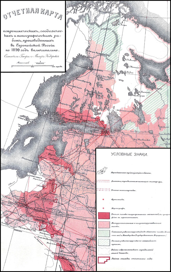
Survey of European part of Russian Empire y. 1890 (link)
Map showing survey of European part of Russian Empire, y.1890 (dark red- survey in scale 0,5-verst (1:21000) was done (till 1890), light-red- old survey, red lines - territories where survey was in process)
|
|
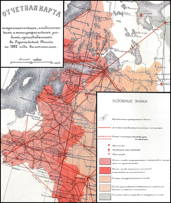
Survey of European part of Russian Empire y.1912 (link)
Map showing survey of European part of Russian Empire, y.1912 (red-lined- survey in scale 0,5 verst (1:21000) done till 1912, dark red - survey in scale 1-verst (1:42000) done till 1912, light-red- old survey)
|
|
|
|
Not a member yet? Click here to register.
Forgotten your password? Request a new one here.
|
|