|
M.K.Radvila's 1613 map of Grand Ducatus of Lithuania
M.K.Radvila's map 1613 of Grand Duchy of Lithuania. Present map from Blaeu atlas (1631-50).
More you can read in Lithuanian (or translated by Google text)
|
|
Gerhard Mercator. Lithuania. 1595
Gerhard Mercator. Lithuania. Duisburg 1595
|
|
Gerhard Mercator. Lithuania.1595 (verso)
Gerhard Mercator. Lithuania. Duisburg 1595 (verso)
|
|
F. de Witt. Magni Ducatus Lithuaniae tabula...1690.
Frederic de Witt. Magni Ducatus Lithuaniae tabula, divisa tam in palatinatus, quam subjacentes castellanias. Amstardam 1690.
|
|
M.Seutter. Novissima et accuratissima Magnis Ducatus Lithuaniae...1720
M.Seutter. Novissima et accuratissima Magnis Ducatus Lithuaniae in suos Palatinatus et Castellanias divisae delineatio... Augsburg. 1720(?)
|
|
Olaus Magnus The Carta marina 1539
The Carta marina (Latin "map of the sea" or "sea map"), created by Olaus Magnus in the 16th century, is the earliest map of the Nordic countries that gives details and place names.
The map was created in Rome by the Swedish ecclesiastic Olaus Magnus (1490�1557), who arrived on a diplomatic visit for the Swedish government and stayed on, likely because his brother Johannes Magnus became involved in a religious feud with King Gustav I of Sweden.
The notes on the map in Latin were translated by Olaus into Italian and German. It is generally considered that the "A description of the Northern peoples" (Historia de gentibus septentrionalibus, Rome, 1555) is a much larger commentary on the map.
Source: Wikipedia
|
|
Nicolas d'Abbeville Sanson. Part of Lithuania - district of Vilnius and Trakai. 1665 y.
Nicolas d'Abbeville Sanson (1600-1667). Map of part of Lithuania - district of Vilnius and Trakai, 1665.
|
|
Nicolas d'Abbeville Sanson (1600-1667). Map of part of Lithuania - district of Polock, Witebsk, Mscislav and Minsk, 1665.
Nicolas d'Abbeville Sanson (1600-1667). Map of part of Lithuania - district of Polock, Witebsk, Mscislav and Minsk, 1665.
|
|
Nicolas d'Abbeville Sanson (1600-1667). Map of part of Lithuania - district of Minsk and Mscislav, 1665.
Nicolas d'Abbeville Sanson (1600-1667). Map of part of Lithuania - district of Minsk and Mscislav, 1665.
|
|
Nicolas d'Abbeville Sanson (1600-1667). Map of part of Lithuania - districts of Novogrudek, Brest, Polesia and Minsk, 1665.
Nicolas d'Abbeville Sanson (1600-1667). Map of part of Lithuania - districts of Novogrudek, Brest, Polesia and Minsk, 1665.
|
|
F.Reilly, Grand Duchy of Lithuania, NO part, 1792.
F.Reilly, Grand Duchy of Lithuania, NO part, 1792.
|
|
F.Reilly, Grand Duchy of Lithuania, NW part, 1792.
F.Reilly, Grand Duchy of Lithuania, NW part, 1792.
|
|
F.Reilly, Grand Duchy of Lithuania, SW part, 1792.
F.Reilly, Grand Duchy of Lithuania, SW part, 1792.
|
|
F.Reilly, Grand Duchy of Lithuania, SO part, 1792.
F.Reilly, Grand Duchy of Lithuania, SO part, 1792.
|
|
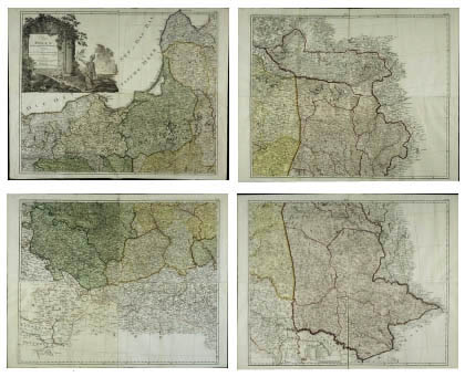
J.Kanter. Regni Poloniae, Magni Ducatus Lituaniae, provinciarum foedere et vasallagio illis junctarum, et regionum vicinarum nova mappa geographica, 1770, 5-th sheet.
Regni Poloniae, Magni Ducatus Lituaniae, provinciarum foedere et vasallagio illis junctarum, et regionum vicinarum nova mappa geographica. Joanne Jacobo Kanter. This set of maps in scale 1:670000 was published in 1770 in color and consists of separate 16 sheets.
The big picture of map Regni Poloniae, Magni Ducatus Lituaniae, provinciarum foedere et vasallagio illis junctarum, et regionum vicinarum nova mappa geographica
|
|
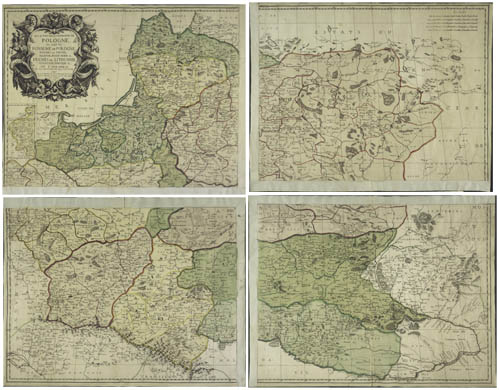
D. F. Sotzmann, Karte von Polen und den angranzenden Provinzen in XVI Blattern, 1793, I part (I, II, V, VI sheets)
The map Karte von Polen und den angranzenden Provinzen in XVI Blattern D.F.Sotzmann prepared and published in 1793 in Berlin. Map in scale 1:1100000 has dimension 96x116 cm, consists of 16 separate sheets (sheets are assembled in four).
The big picture of map Karte von Polen und den angranzenden Provinzen in XVI Blattern
|
|
Claudius Ptolemy. Tabula Europae descriptio octava
Claudius Ptolemy Tabula Europae descriptio octava. About 1480. Sarmatia from Baltic to Blac see.
|
|
Abraham Ortelius. Theatrum Orbis Terrarum. Polonia. 1570
Abraham Ortelius. Theatrum Orbis Terrarum. Polonia. 1570.
|
|
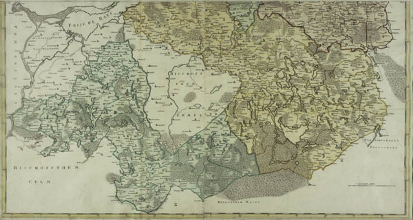
Regnum Borussiae episcopatus Warmiensis, palatinatus Mariaeburgensis et Culmensis, 1763
Regnum Borussiae episcopatus Warmiensis, palatinatus Mariaeburgensis et Culmensis cum territorio Dantsicano et ichnographia urbis regiomontis Ausp. Acad. Reg. Scient. Ber. N.p. 1763.
Partly colored engraved map in 6 sheets not joined together. Each about 48x57,5 cm. Scale 1:300000.
Map probably edited by Homann Heir after a map by the Polish cartographer Jan Wladyslaw Suchodolec (von Suchodoletz), first published about 1732-39.
Map covers the area from Memel (Klaipeda) to Danzig after the coast and into Soldau (Dzialdowo) and Oletzko.

General view of map
|
|
LES ESTATS DE LA COURONNE DE POLOGNE, 1769, G.Sanson
LES ESTATS DE LA COURONNE DE POLOGNE, ou sont les ROYAUME DE POLOGNE, DUCHES DE PRUSSE, MAZOVIE, RUSSIE NOIRE, &c. DUCHES DE LITHUANIE VOLHYNIE, PODOLIE, … DE L’UKRAINE, Sr. SANSON d’Abbeville.
Engraving on 4 sheets, 92 × 121 cm.
Scale 1 : 1200000.
Map prepared by Guillaume Sanson, Paris, 1676, reprinted by Gilles and Didier Robert de Vaugondy, Paris, ca. 1769. Paris.
General view of map
|
|
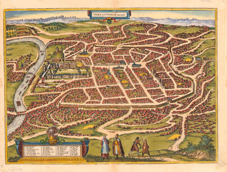
Panorama (Plan) of city Vilnius, Bruynen G., Hoogenbergh F., 1581
Panorama (Plan) of city Vilnius, Bruynen G., Hoogenbergh F., 1581
 |
 |
|
Panorama (Plan) of city Vilnius, Bruynen G., Hoogenbergh F., 1581
Full size (link)
|
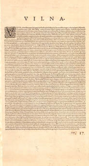
Description of city Vilnius
Full size (link)
|
| Thanks Mr. Ryszard Hubisz, Poland |
|
|
|
Map of district Klaipėda (Memel) published by Juzef Naronowicz-Naronski in 1670.
Famous cartographer of Grand Duchy of Lithuania (XVII c.) Juozas Narūnavičius – Naronskis (Józef Naronowicz-Naroński, Naronovičius) with son and other cartographers in 1660-1670 has prepared and published map of whole Prussia which consists of 44 maps of separate districts. 35 maps survive till now. One of maps from this set was Map of district Klaipėda (Memel) published in 1670. Original name of map (in Latin, as content) - Districtus Memeliensis (Memel) in Ducatu Prussiae eiusque tractu Schalavoniae (Schalauen). On this map view of city Klaipėda (Memel) is given.
Map has dimmensions 85,5 x 48 cm., scale 1:100000; map orientated to east, published in 1670.
.jpg)
General view of map Districtus Memeliensis (Memel) in Ducatu Prussiae eiusque tractu Schalavoniae (Schalauen), 1670, 1:100000
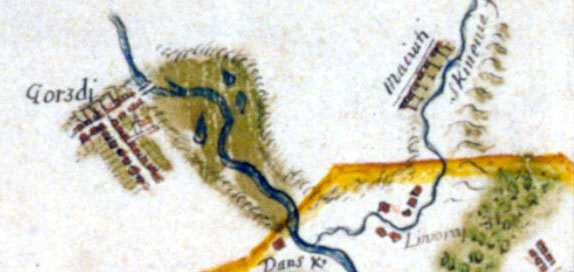
Fragment of map Districtus Memeliensis (Memel) in Ducatu Prussiae eiusque tractu Schalavoniae (Schalauen), 1670, 1:100000; Gargždai and surroundings

Panorama of city Klaipėda (Memel) on map Districtus Memeliensis (Memel) in Ducatu Prussiae eiusque tractu Schalavoniae (Schalauen), 1670, 1:100000
|
|
Map of Dukedom Biržai, 1645 by Józef Naronowicz-Naroński.
Famous cartographer, mathematician, architect, military engineer [colonel] of Grand Duchy of Lithuania (XVII c.) Juozas Narūnavičius – Naronskis (Józef Naronowicz-Naroński, Naronovičius) among many maps beeing in duke Radwila employ in 1645 prepared map of Dukedom Biržai.
More about Dukedom Biržai (link).
More about cartographer Juozas Narūnavičius – Naronskis (Józef Naronowicz-Naroński, Naronovičius) (link in EN), (link in PL); (link in LTU);
Original name of Map of Dukedom Biržai - (in Polish as all content on map) - „MAPPA Księstwa Biržanskiego Dostatecznie y doskonale sprawdziwą dimensią Nowo uczyniona Roku panskiego 1645 Jašnie oswieconemu XIM na Biržach y Dubinkach Januszowi Radziwillowi (...) unižony sluga, autor delineaty tey pracy y ręki swei wlasney oddaię y ofiaruię Jozeph Naronski".
Size of map 74x59 cm., scale 1:12000, map orientated to SE (120 degrees). Map is colored, content in sepia, woods in green, boundaries of holdings in red. On top in left side of map arm of Radvila's family was represented.
L.: Raimonda Ragauskienė, Deimantas Karvelis. 1645 m. Juzefo Naronovičiaus - Naronskio Biržų kunigaikštystės žemėlapis. Radvilų valdos istorija ir kartografija.
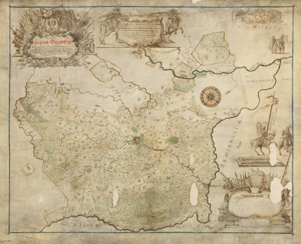
General view of map of Dukedom Biržai, 1645, 1:12000. Link to enlarge map THERE
|
|
La Prusse divise en ses balliages..., Fridric Guillaume, 1726 (Link to full size map)
Map prepared by Fridric Guillaume "La Prusse divise en ses balliages et tres humblement presente a sa majeste Fridric Guillaume" covers territories of Prussia. Scale of map - 1:742000, map published in 1726. Size of map - 53x51 cm. Interesting that map shows territories not only Prussia but also territories of boundaries of Grand Duchy of Lithuania (details).
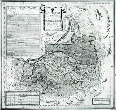
General view of map La Prusse divise en ses balliages et tres humblement presente a sa majeste Fridric Guillaume (1726, 1:742000), full size map (link).
|
|
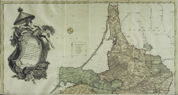
Magna mappa Geographica Borussiae Regnum... Oesfeld, C.L, Sauerbrey, N.F., 1772 - 1786
Map of Prussia (including district of Klaipėda [Memel]) consists of 4 separate maps, each size 47x49 cm. Publisher Carl Ludwig von Oesfeld, creator - Gerhard, drawer - von Sauerbrey. Map published in 1772-1786. Original name of map -"Magna mappa geographica Borussiae regnum exact exhibens, in qua non tantum limites correcti sed etiam principaliora loca, civitates, oppida & praefecturae omni studio designata sund". Scale - 1:333333.
 |
 |
| General view of map Magna mappa geographica Borussiae regnum exact exhibens, in qua non tantum limites correcti sed etiam principaliora loca, civitates, oppida & praefecturae omni studio designata sund" (1772-1786, 1:333333) |
|
|


